Your Link to Muskoka's Water!
Geology & Ecology
The entire Muskoka River Watershed is situated on the Canadian Shield, which dates from the middle to late Precambrian Age. Soils are generally sandy and shallow in depth atop the underlying bedrock. The watershed is mainly forested, with mixed hardwood (i.e. maple, birch and oak) and coniferous (i.e. White and Red pine, spruce, tamarack and hemlock) species.
Muskoka is an area of transition from the northern boreal forest to the mixed forests in the south.
The Muskoka River Watershed contains predominantly cool and coldwater fish species. In the upper part of the watershed, several lakes and streams are considered coldwater, and support species such as Lake trout and Brook trout.
Soils
The Muskoka River Watershed is located on the Canadian Shield. The shield is characterized by very thin soil with rocky outcroppings. The thin, nutrient poor soils and surrounding environment dictates the vegetation that can grow and limits the amount of nutrients that flow to waterbodies from the watershed.
The North (Algonquin dome in Huntsville and Lake of Bays) contains mainly conifers:
- White pine
- Black spruce
- White spruce
- Jack pine
- Balsam fir
The South (the barrens in Gravenhurst, Muskoka Lakes and Georgian Bay) contains mainly hardwoods:
- White Pine
- Sugar maple
- Yellow birch
- Red oak
- Beech
Vegetation plays a large part in determining soil characteristics. In conifer dominated forests the soil is likely to be acidic and in hardwood forests soils are more likely to be non-acidic. Muskoka contains both of these vegetation communities.
Forest Type
In Ontario, there are four main regions of forest types. They are the Hudson Bay Lowlands, Boreal Forest, Great Lakes-St. Lawrence Forest, and Deciduous Forest. Muskoka is located in the Great Lakes-St. Lawrence Forest region.
This region is a transitional zone between deciduous forests of the south and coniferous boreal forests of the north.
In this region, coniferous trees include:
- White pine
- Red pine
- Eastern hemlock
- White cedar
Deciduous broad-leaved species include:
- Yellow birch
- Sugar maple
- Red maple
- Basswood
- Red oak
Some species that are more common in the boreal forest also exist in Muskoka, such as:
- White spruce
- Black spruce
- Jack pine
- Aspen
- White birch
Forest Health
Organizations such as the Ontario Woodlot Association have developed many resources to assist landowners who wish to explore management options for their forests, including:
- A Landowner’s Guide to Selling Standing Timber booklet
- A Landowner’s Guide to Careful Logging booklet
- The Landowners' Guide to Controlling Invasive Woodland Plants booklet
Wetlands
Wetlands are a crucial part of a watershed. The primary function of wetlands include:
- Control and storage of surface water and the recharge and discharge of groundwater
- Maintain and improve water quality
- Aid in flood control
- Protect shorelines from erosion
- Trap sediments which would otherwise fill watercourses
- Provide wildlife habitat
- Provide recreational opportunities
Fish and Wildlife
Muskoka features:
- Over 250 species of birds
- Almost 50 kinds of mammals
- 25 types of reptiles and amphibians
- Dozens of species of fish
They all play a vital role in the ecology of the Muskoka River Watershed. Some of the common wildlife species you might spot in Muskoka include:
- Moose
- Black bear
- White-tailed deer
- Five-lined skink
- Loon
- Great blue heron
- Osprey
- Lake trout
- Eastern massassaga rattlesnake
- Eastern hognose snake
Wildlife within the Muskoka River Watershed
The life cycle of many Muskoka wildlife species is directly related to the river (including its tributaries and lakes) and the land-water shoreline interface (to provide habitat and food sources).
An example of this complex linkage would be the wetland areas found along the shorelines of rivers and lakes. Some of the animals dependent on these wetlands include:
- Waterfowl for their nesting and staging areas.
- Furbearers and mammals for habitat, protection, and feeding areas.
- Reptiles and amphibians depend on wetlands for all or parts of their life.
- Osprey, eagles and herons benefit from the shallow water feeding opportunities.
Fish within the Muskoka River Watershed
In the Muskoka River Watershed you are most likely to find cool and coldwater fish species.
In the cold water lakes and streams in the upper part of the watershed you may find:
The large lakes in the watershed are fairly deep (50+ m) and cold, and are sustainable for communities of:
Much of the lower part of the watershed (with the exclusion of the large lakes) is considered coolwater habitat, sustaining communities of:
- Walleye
- Northern pike
- Muskellunge
- Smallmouth bass
- Yellow perch
- Pan Fish (Black crappie, Pumpkinseed, Bluegill and Rock bass)
Lake Trout Lakes in Muskoka
Muskoka has many excellent deep coldwater lakes that sustain natural Lake trout populations. Many lakes also benefit from the Ministry of Natural Resources and Forestry (MNRF) stocking program. The following lakes in Muskoka are managed as Lake trout lakes by the MNR:
| Lake | Area Municipality | Lake | Area Municipality |
| Bella | Lake of Bays | Lake of Bays | Lake of Bays |
| Bigwind | Bracebridge | Mary | Huntsville |
| Blue Chalk | Lake of Bays | Muskoka | Muskoka Lakes |
| Bonnie | Bracebridge | Oxbow | Lake of Bays |
| Buck | Lake of Bays | Peninsula | Lake of Bays |
| Camp | Lake of Bays | Pine | Bracebridge |
| Cardwell (Long) | Muskoka Lakes | Rebecca | Lake of Bays |
| Clear | Bracebridge | Red Chalk | Lake of Bays |
| Clearwater | Gravenhurst | Rosseau | Muskoka Lakes |
| Dotty | Lake of Bays | Seventeen Mile | Lake of Bays |
| Eighteen Mile | Lake of Bays | Shoe | Lake of Bays |
| Fairy | Huntsville | Skeleton | Muskoka Lakes |
| Fifteen Mile | Lake of Bays | Solitaire | Lake of Bays |
| Harp | Huntsville | South Tasso | Lake of Bays |
| Jerry | Lake of Bays | Vernon | Huntsville |
| Joseph | Muskoka Lakes | Young | Muskoka Lakes |
Species at Risk
A Species at Risk is any naturally-occurring plant or animal in danger of extinction or of disappearing from the province. Once classified as "at risk", they are added to the Species at Risk in Ontario (SARO) List.
Designation
There are 2 levels of designation for Species at Risk. They can be listed provincially and/or federally.
Federal
The Committee on the Status of Endangered Wildlife in Canada (COSEWIC) is a committee of academics, independent specialists, Aboriginal knowledge-holders, government biologists, museum staff and independent experts who act as the authority for assessing the conservation status of wildlife species that may be at risk of extinction in Canada.
Provincial
The Committee on the Status of Species at Risk in Ontario (COSSARO) is another committee of experts whose role is to review COSEWIC species at risk and classify those that occur in Ontario.
Legislation
The Endangered Species Act (ESA) 2007 this the provincial legislation dealing with the protection and recovery of Species at Risk and their habitats.
Canada's Species at Risk Act (SARA) is a key federal government commitment to prevent wildlife species from becoming extinct and secure the necessary actions for their recovery. It provides for the legal protection of wildlife species and the conservation of their biological diversity.
Classification
There are 5 classifications for species at risk in Ontario:
Extinct (Ext) - a native species that no longer lives anywhere in the world.
Extirpated (Exp) - a native species that no longer exists in the wild in Ontario, but still exist elsewhere.
Endangered (End) - a native species facing extinction or extirpation.
Threatened (Thr) - a native species at risk of becoming endangered if steps are not takes to address factors threatening it.
Special Concern (Sc) - a native species that is sensitive to human activities or natural events which may cause it to become endangered or threatened.
Threats
Plants and animals may become at risk for many reasons, including:
- Habitat loss e.g. wetlands filled in, forests cut down, grasslands ploughed and fenced
- Habitat fragmentation e.g. roads constructed through natural areas, development in sensitive habitat
- Competition from introduced and/or invasive species
- Traffic mortality
- Illegal harvesting (poaching) and/or overhunting
- Pollution and chemicals
- Disease
- Predation
Species at Risk in Muskoka
There are currently 48 Species at Risk in the Muskoka-Parry Sound area.
Which species are at risk in Muskoka?
Protecting Species at Risk
Each of us has an important role to play in the recovery of Species at Risk.
What is a Watershed?
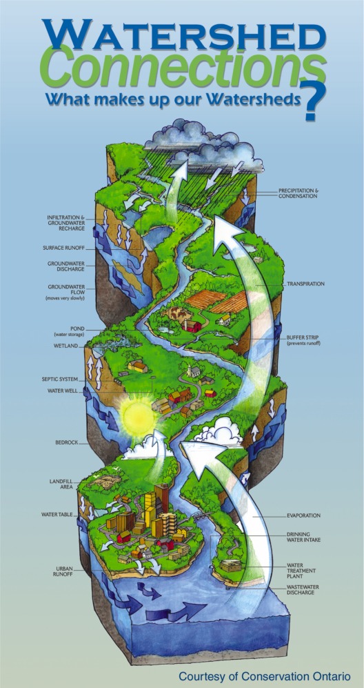 A watershed is an area of land that drains to a river, lake or stream. It includes all the land, air, plants and animals within its borders. Land forms such as hills or heights of land largely determine the boundaries of watersheds and direct the speed and path of its rivers.
Each watershed has a unique mixture of land and water habitats: from wetlands, rivers and lakes to forests, grasslands, farms, towns and cities.
All living things depend upon the continuous cycling of water and nutrients through ecosystems. The effects of forestry, agriculture, industry and urbanization are all recorded in the water as it flows along its path. For better or worse, each tributary stream, wetland or spring which joins together reflects the health of the region in which it is found.
Watersheds fulfill three primary functions: to capture water, to filter and store water in the soil and to release water into a waterbody. Within the complex living system of a watershed, everything is connected.
Thinking of a watershed as a giant sponge helps explain the connections between all parts of a watershed and how a river like the Muskoka River can always be flowing. As precipitation falls, it is stored in the watershed’s land and waterbodies (the giant sponge) and slowly released through shallow water discharge into the river.
Learn More
- The Atlas of Canada - Watersheds
- US Environmental Protection Agency - Healthy Watersheds
- Conservation Ontario - Watershed Stewardship
Muskoka's Watersheds
Muskoka consists of four primary watersheds and seventeen secondary watersheds.
Primary Watersheds

Georgian Bay Secondary Watersheds
- Georgian Bay
- Twelve Mile Bay
- Tadenac Lake
- Moon River
- Musquash River
Severn River Secondary Watersheds
- Severn River
- Morrison Lake
- Sparrow Lake
Muskoka River Secondary Watersheds
- Lake Joseph
- Lake Muskoka
- Lake Rosseau
- North Branch Muskoka River
- South Branch Muskoka River
- Lake Vernon
- Mary Lake
- Lake of Bays
Black River Secondary Watershed
- Black River
Flow of Water
There are four primary watersheds in Muskoka. The Black and Severn River Watersheds flow through the Severn River to Georgian Bay and the Muskoka River and Georgian Bay Watersheds flow directly to Georgian Bay through the Moon, Musquash or other smaller rivers in the Township of Georgian Bay.
Muskoka River Watershed
The headwaters for the Muskoka River are found in Algonquin Park, and flow southwesterly for a distance of about 210 km to release into Lake Muskoka before it continues into Georgian Bay through the Moon and Musquash Rivers.
The Muskoka River Watershed is the largest watershed in Muskoka. The watershed:
- Measures over 62 km at its widest section
- Covers an area of around 466,000 hectares (4,660 km2)
Watershed Communities
- Dwight
- Dorset
- Baysville
- Huntsville
- Port Sydney
- Bracebridge
- Gravenhurst
- Bala
- Port Carling
- MacTier
Subwatersheds
The Muskoka River Watershed is divided into three secondary subwatersheds: the North and South Branches, and the Lower Muskoka subwatershed. It is further divided into eight tertiary watersheds.
The North and South Branches comprise roughly two-thirds of the eastern part of The District Municipality of Muskoka. Beginning in the highlands of Algonquin Park they flow southwesterly, uniting in Bracebridge. They then continue to flow into Lake Muskoka.
The Lower Muskoka subwatershed receives the inflow from the North and South Branches as well as Lake Joseph, Lake Rosseau, and Gull and Silver Lakes in Gravenhurst.
Black River Watershed
The Black River begins in the Haliburton Highlands and flows southwest passing through the southeast corner of Muskoka. The portion of the watershed in Muskoka is approximately 360 km2. Vankoughnet is the only community in Muskoka in the Black River Watershed.
Severn River Watershed
The Severn River is the lower end of the Trent-Severn Historic Waterway, managed by Parks Canada. It flows from Lake Simcoe and Lake Couchiching to Georgian Bay at Port Severn. The portion of this watershed in Muskoka is approximately 357 km2.
Watershed Communities
- Severn Bridge
- Kilworthy
- Barkway
Subwatersheds
The subwatersheds in the Severn River Watershed includes Kahshe Lake, which flows directly into Sparrow Lake. Morrison Lake, Six Mile Lake and Gloucester Pool all flow directly into the Severn River just upstream of the mouth at Port Severn.
Georgian Bay Watershed
Georgian Bay is a large bay in Lake Huron and receives all the water from the watersheds in Muskoka. Besides the major watersheds identified on this page, there are several smaller watersheds that flow directly into Georgian Bay from the western portion of Muskoka.
The land area represented by these smaller watersheds is approximately 900 km2.
Watershed Communities
- MacTier
- Honey Harbour
- Port Severn
Subwatersheds
The subwatersheds that make up the Georgian Bay Watershed in Muskoka include Brotherson/Nine Mile Lake in the southern portion of the Township of Muskoka Lakes, and the Moon, Musquash and Go Home Rivers in the Township of Georgian Bay.